Explaining Anvils, the Incredible Cloud Formations That Engulf the Sky


We’ve all gawked at beautiful clouds before, but we never really think about how those clouds formed. One of the most beautiful sights in nature is a huge thunderstorm bubbling up on the horizon, smacking the top of the atmosphere and spreading out like a giant umbrella. Here’s a look at how these anvils form.
Thunderstorms are responsible for some of the most incredible images nature can produce, and there are dozens of different types of clouds that come with these beastly bursts of muggy air. Regular ol’ cumulus and cumulonimbus clouds are beautiful on their own, but there are different formations and appendages that can make these clouds even more spectacular.
Anvils can dominate the sky and warn of impending danger just as easily as they can act like a textured canvas on which the sunset paints its beautiful oranges and red. These clouds are called “anvils” because of their uncanny resemblance to the anvils blacksmiths use to shape metal and maim Wile E. Coyote.

These impressive cloud formations are a natural result of convection. The development of a thunderstorm is pretty basic. Air near the surface warms unevenly, and some pockets of air wind up warmer (and less dense) than their surroundings, allowing them to freely rise through the atmosphere like a balloon. Once this pocket of rising air cools to the temperature of its environment (or colder), it stops rising and begins to sink. These columns of rising air—called updrafts—can be pretty strong, rising into the atmosphere at more than 100 MPH in the most intense thunderstorms.
The vast majority of thunderstorms aren’t strong enough to reach the top of the atmosphere, but when they do, the results are phenomenal. The point of the atmosphere at which a rising pocket of air becomes neutrally buoyant—or stops rising—is known as the “equilibrium level,” and we can easily find the equilibrium level using data collected by weather balloons. The equilibrium level can coincide with the tropopause—or the boundary between the troposphere (our layer of the atmosphere) and the stratosphere—but it’s usually just beneath it.
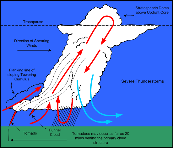
When updrafts hit the equilibrium level, one of two things can happen—the air spreads out as if it hit a ceiling, or if the updraft is powerful enough, the air breaks through the layer and creates what’s known as an “overshooting top.” Storms with overshooting tops are usually severe, as updrafts this much oomph can support the weight of some ugly hailstones at the least.

The photo above is one of the most widely-circulated thunderstorm pictures on the internet; it was taken by an astronaut aboard the International Space Station back in February 2008 as they passed over the storm in Western Africa. It’s a classic example of an anvil and its associated overshooting top, with a great view of the parent thunderstorm below. You can see similar sights if you fly frequently during storm season or if you have an excellent, unobstructed view of the horizon.
For a more recent example of anvils, here’s a look at a SKEW-T chart, plotting data taken from Tuesday night’s observation at Dallas-Fort Worth Airport. The region saw some robust supercells last night, many of which produced large hail, flooding rains, and even a couple of tornadoes.

We can calculate the temperature of rising pockets of air using weather balloon data, and this helps us figure out how quickly air will rise, giving us an idea of how intense the thunderstorms could be. We measure this kind of instability using a metric known as “CAPE,” or Convective Available Potential Energy. The greater the CAPE, the stronger the thunderstorms can grow.

The sounding from Dallas-Fort Worth last night showed a pretty nice area of CAPE, indicating that the atmosphere is ready and willing to produce some good thunderstorms. The sounding showed us that, at the time of the weather balloon launch, air would start rising at around 1,500 feet above ground level, continuing to freely rise through the atmosphere until it reached the equilibrium level around 46,000 feet.
Once the updrafts hit the equilibrium level, the air fans out in all directions, allowing a thick ceiling of cirrus clouds to extend out and away from the hulking cumulonimbus cloud.

The atmosphere all across Texas was ripe for thunderstorms last night. Here’s an excellent example of a supercell thunderstorm developing in western Texas (a few hundred miles west of Dallas)—this storm ultimately produced hail larger than baseballs. This is also an example of super rapid scan satellite imagery, which takes a snapshot of the atmosphere every minute.
[There was a video here]
Widespread anvils with large pockets of overshooting tops are indicative of severe weather, so if you see one of these monstrous formations crawling towards you one day, get ready to find sturdy shelter once it arrives. At the very least, anvils are extremely photogenic, so make sure you have a camera within arm’s reach when you know thunderstorms are possible.
[Top Image by Daniel Rodriguez via Flickr (and cropped by the author) | Edge of an anvil taken by the author | Storm from space via NASA | SKEW-T/storm examples adapted from SPC soundings and this drawing | Video created from a gif posted by Colorado State University]