Today Is the Start of Meteorological Summer


Welcome to meteorological summer. For the next three months, we're going to sweat, run for our lives, and anxiously wait for student loan debt to kick in. It's already off to a rocky start, with a 20% chance of tropical development in the Gulf of Mexico this week and a severe weather outbreak in the midwest.
Hurricanes
The National Hurricane Center (NHC) began issuing regular advisories this morning. Advisories are another name for tropical cyclone forecasts that are issued every six hours — they come out at 2AM, 8AM, 2PM, and 8PM. When a tropical system develops in either the Atlantic or the eastern Pacific, the agency will issue advisories on the system at the same six hour intervals until it threatens land, at which point they'll issue forecasts and updates every three hours.
The NHC also made a few changes to the forecasts themselves this year, the most visible of which is breaking with the standard of TYPING FORECASTS IN ALL UPPER-CASE LETTERS (which was done for legibility and uniformity) by issuing its products in normal case. This should be welcome news to the general public, but it'll take some getting used to for weather enthusiasts.

The agency is already watching an elongated area of low pressure over the southern Gulf of Mexico, which currently has a 0% chance of developing over the next two days, but a 20% chance of developing within the next five days. Models have consistently hinted at this system becoming better organized later this week as wind shear starts to lighten up, so folks anywhere around the Gulf need to keep an eye on it.
Severe Weather
The north side of a strong ridge of high pressure over the southeastern United States will serve as the focus for a potentially significant severe weather outbreak on Tuesday and Wednesday, including an elevated risk for damaging straight-line winds, large hail, and tornadoes. The setup is conducive to the development of bow echoes/squall lines/lines of severe thunderstorms, which will serve as the source for the damaging winds.
A slight risk (2/5 risk) for severe weather on Tuesday exists in the yellow-shaded zone, according to the Storm Prediction Center.

Here's the probability map, showing the chance for severe weather within 25 miles of any point within the shaded area. A 30% chance for severe weather means that the odds of seeing damaging winds, large hail, or tornadoes is 30x higher than normal in the shaded areas. The black hatching indicates the risk for significant severe weather.

Here's the risk for Wednesday, shifting east but too far out for the SPC to put specifics on just yet.

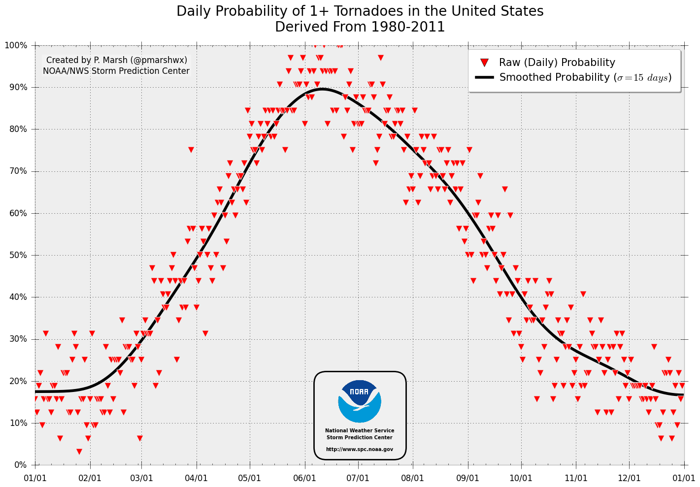
It's worth noting that this week is historically the most active for tornadoes in the United States, with chances of seeing at least one tornado touch down anywhere in the country growing to near 90% by next weekend.
[Images: AP / NHC / SPC / SPC / SPC]