Welcome to Tornado Season


Today begins the second quarter of 2014. You made it through a long, hellish winter and the light at the end of the tunnel isn't from a snow plow for once. April is a beautiful time of the year. It brings warmer weather, flowers blooming, birds chirping, bees buzzing, and the atmosphere's most violent phenomenon: tornadoes.
Tornado Season

April begins the climatologically active period known as "tornado season," even though tornado outbreaks are possible at any time during the year. It is during the next three months that the United States sees a massive uptick in the number of recorded tornadoes.
In fact, the Storm Prediction Center (SPC) analyzed the probability of at least one tornado in the United States on any given day, and based on 32 years worth of data, April 2 begins a five-month long stretch when we're more likely than not to see a tornado.
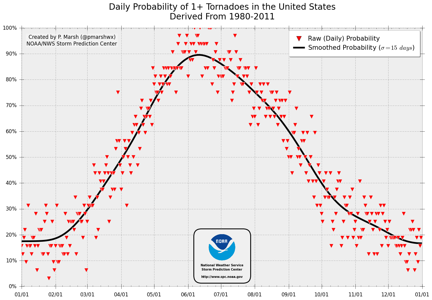
The trend peaks at the beginning of June, when the SPC found that the country has almost a 90% chance of seeing at least one tornado every day for the first week of the month.
Of course, we're not going to see a tornado every day, but the overall weather pattern becomes more conducive for violent tornado outbreaks as the atmosphere begins to warm up. Warmer temperatures and ample Gulf moisture breeds instability, allowing bigger and stronger thunderstorms to develop and tap into the jet stream, creating wind shear that lets storms rotate and potentially produce a tornado.
Watch vs. Warning
It's always worth going over the difference between a tornado watch and a tornado warning, since so many people confuse the two terms.
A tornado watch means that conditions are favorable for the development of tornadoes, and that you should stay alert for rapidly changing conditions.
A tornado warning means that a possible tornado is imminent and you need to take immediate action to protect yourself by getting to shelter.
Tornado Alley
Tornadoes have been reported in every state in the country — less in Alaska than Alabama, obviously — but just because an area doesn't traditionally see Oklahoma-like outbreaks doesn't mean they're immune from the occasional twister or two.
Most of the tornadoes in the United States develop in two distinct regions of the country — the traditional Tornado Alley, and a (relatively) new region called "Dixie Alley."

Tornado Alley is that area in the middle of the country that everyone is taught about in elementary school. The track of weather systems, the flat terrain, and its proximity to the ample moisture of the Gulf of Mexico allow storms in this region to easily produce massive tornadoes during the spring months. Some of the worst twisters in American history have occurred right in the middle of the Alley in Oklahoma (twice in the same town, even) and Kansas.

Tornadic supercell thunderstorms in the middle of the country tend to take on the classic "hook echo" shape that almost everyone is familiar with, like the one pictured above from the historic 1999 Bridge Creek-Moore F5 tornado.
However, it's not a good idea to look for the classic hook whenever you're under a tornado warning. Not all thunderstorms come with the hook and pendant indicative of a tornado. Most tornadoes are wrapped in rain and impossible to see purely using reflectivity (precipitation) images generated by radar.
Meteorologists use velocity (wind) imagery produced by Doppler radar to see rotation within a thunderstorm, and it's almost always based on that information that they issue a tornado warning.
Dixie Alley

The southeastern United States — including Arkansas, Louisiana, Mississippi, and Alabama — is often referred to as "Dixie Alley" due to its tendency to see violent tornado outbreaks in the same vein as the traditional Tornado Alley sees (albeit less frequently). One of the worst tornado outbreaks in American history started in Texas and ramped up over Dixie Alley between April 25 and April 28 in 2011. Coming in at over 350 twisters, this four day period saw more tornadoes reported in one outbreak than ever before. It produced 4 EF-5 tornadoes, 11 rated EF-4, 22 rated EF-3, and hundreds more that were less intense.
The outbreak became a defining moment for the state it hit the hardest — Alabama. The Cotton State saw over 200 deaths on the afternoon of the 27th and billions of dollars worth of damage. Birmingham, Alabama-based meteorologist James Spann became a national figure because of his incredible, continuous on-air coverage of the twisters, a small segment of which is seen in the video clip above from when an EF-4 tornado tore through Tuscaloosa, Alabama.
The Enhanced Fujita Scale

The strength of tornadoes is estimated based on the Enhanced Fujita Scale, originally created by meteorologist Ted Fujita in the mid-1900s and modernized ("enhanced") with some adjustments in 2007.
National Weather Service meteorologists survey the damage left behind by a tornado and use the EF-Scale to estimate how strong the twister's winds were. EF-0 is the weakest tornado, and EF-5 (winds >200MPH) is the strongest — obviously, weaker tornadoes are much more common than stronger ones.
I wrote an article for the Washington Post's Capital Weather Gang last summer in which I found that the frequency of violent (EF-4 and EF-5) tornadoes is actually going down with time. While there are some glaring issues with comparing tornado reports written in 1950 to ones written in 2013, it's an interesting trend that actually goes against logic.
Since the EF-Scale estimates the strength of a tornado based on damage rather than direct observation of its winds (which is impossible in almost all cases), one would think that the population explosion and spread into previously-unpopulated areas would lead to an increase in destructive tornadoes.
Last year, a Doppler-on-Wheels (weather radar attached to a flatbed truck) measured winds in the El Reno, Oklahoma tornado at over 200 MPH, which would classify it as an EF-5. However, the National Weather Service refused to assign it the highest rating based on Doppler radar measurements, sticking with its initial EF-3 rating assigned after a survey of the damage the storm produced.
While the downtick in violent tornadoes seems like it goes against logic, it could be explained by dumb luck and improved building codes. As I wrote in the CWG article:
The population explosion may account for why there's so much destruction when a major tornado occurs, but why isn't there as much EF-4 or EF-5 damage as there was back when this type of recordkeeping began? The answer likely lies partially in luck, and partially in the quality of building construction. It's rare for the strongest part of a tornado to hit any building, let alone a well-built one.
The amount of damage it takes for a tornado to be classified as an EF-5 is immense – the destruction of a public school building or a hospital, for one, or an anchored bank vault being tossed – so it's a good thing that they aren't too common.

For example, above is an annotated photo from the American Meteorological Society showing the "graduation" of tornado damage over one block in a residential neighborhood. The house on the bottom-right sustained EF-5 damage (winds estimated >200 MPH), while homes just a few streets away sustained minimal tornado damage.
Unless a tornado hits a structure — or we can directly measure its winds, à la DOROTHY from the movie Twister or a Doppler-on-Wheels — we won't know its true wind speed or be able to estimate it with the EF-Scale.
Predictions for This Year
Everyone wants to know how bad this spring's tornado activity will be compared to the last couple of years. There is no real answer to this question. AccuWeather says that there may not be that many outbreaks this April due to "the lingering chill impacting a significant part of the nation," but that's from AccuWeather so take that as you will.
As I wrote last week, don't focus on the number of tornadoes that occur in an outbreak or in a year, because every individual tornado is dangerous in its own right.
What About Climate Change?
Climate change is real and it is happening, regardless of how much your political persuasion makes you want to shout "NO!" and ignore the scientific evidence to the contrary.
After the devastation seen in 2011 — a year in which we saw an unprecedented (to modern standards) 700+ tornado fatalities — and the major tornadoes in Oklahoma last spring, many people wanted to know if climate change would affect the frequency of tornadoes.
The answer is "probably not." Tornadic thunderstorms need two major ingredients to form: instability (warm, moist air) and wind shear. While a warming atmosphere would increase instability — thereby increasing the odds of severe thunderstorm development — a warmer atmosphere would also create less wind shear, which would prove detrimental to the development of tornadoes.
How to Prepare
Have a plan for what to do in case you need to take shelter at home, at work, at school, or when you're in your car. Oh, and get a weather radio.
No, seriously. Get a weather radio.
Tornado Threat This Week

The Storm Prediction Center predicts a "daily severe weather risk through Thursday," with the outbreak on Thursday potentially packing quite a punch. If you live in any of the shaded areas on the above three maps, stay tuned to your local weather forecasts for potential watches and warnings.
[Images via: WIAT / SPC / NOAA / Gibson Ridge / SPC / WTVR / AMS / SPC]